Integrated drone technology with AI & ML Technology made drill and blast optimization visually interpret the data as well as make informed decisions based on the study analysis. Drones create high-resolution 3D maps for precise planning of drilling parameters for efficient fragmentation and reduced vibration. Drones equipped with sensors and cameras collect real-time data on blast results for analysis using AI and ML algorithms to optimize future parameters for improved safety, efficiency, and cost-effectiveness.
Drones can create high-resolution 3D maps of the terrain and geological features, allowing for accurate and detailed planning of drill hole location, depth, and angle. This can improve fragmentation, reduce vibration, and minimize overbreak and underbreak.
02
Post-blast
drones equipped with sensors and cameras can be used to collect real-time data on blast results, such as fragmentation, muck pile shape and size, and damage to surrounding infrastructure.
Blast smarter, not harder - Contact us to enhance your operations!
Mine Planning & Design
Our experienced mine planning engineers and geologists plan and design operations. We use CAD-based software and Strayos, a cloud-based platform integrated with AI & ML technology, for optimized mine plans and designs. The outputs are exported to Datamine, Deswik, Srupac, Vulcan & Several others empowering these softwares for exponential. While minimizing the impact on the environment and the community, ensuring the economic viability of mine operations, by prioritizing safety, efficiency, and sustainability.
This uses drone technology to create precise 3D models of mines, such as sidewalls, dumps, slopes, and blast designs, without endangering surface mining personnel and is reliable & accurate.
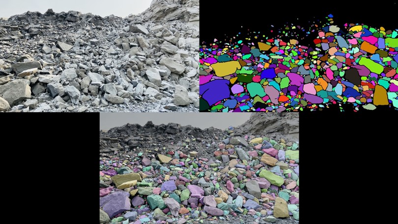
AI in fragmentation analysis
AI technology can measure 2D and 3D muck pile fragmentation automatically using drones and optimize future shot designs with AI fragmentation prediction models that learn from previous shots.
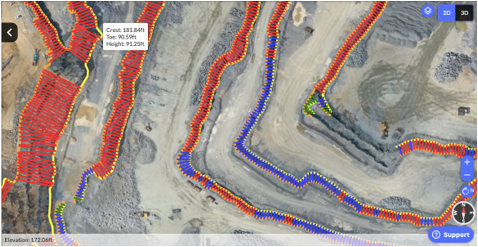
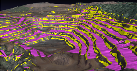
Slope stability analysis
Drone-based technology enhances slope stability analysis in open-pit mines. Drones with LiDAR and cameras provide high-resolution 3D models, identifying potential instability factors like fractures and weathering. Real-time data aids geotechnical engineers in risk assessment, safety measures, and optimizing slope designs for safer and efficient mining operations.
Haul Road Assessment AI
AI technology can detect and assess haul road safety and compliance by automatically identifying parameters such as grade, width, cross-falls, and berm heights.
Your mine's safety matters - Connect with us to go digital!
Subsidence monitoring
UAVs equipped with cameras or LiDAR sensors, integrated with AI/ML algorithms, can monitor subsidence in mining and analyze data to detect changes in ground level, improving risk detection accuracy and efficiency.
Open pit compliance
We provide Services according to (MCDR and IBM) rules with highly advanced Artificial intelligence techniques combined with machine learning. All these compliance for safety audits, safety specifications of various parameters, etc. can be easily captured and compiled.
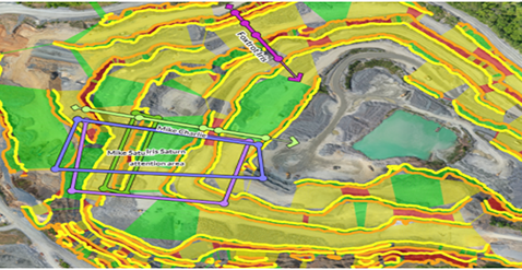
Land acquisition
By adopting an integrated approach that combines drone technology, AI/ML, and GIS solutions, land acquisition efforts can be significantly improved with increased efficiency, accuracy, and better-informed decision-making.
Mine Closure Plan
Our mine rehabilitation plan emphasizes responsible mining practices, using dump stabilization, re-vegetation, and habitat restoration to restore the land and ecosystem. We prioritize stakeholder engagement and leaving a positive legacy for future generations. Drone technology can enhance a Mine Closure Plan by providing high-resolution aerial imagery for monitoring environmental conditions, data collection on air and water quality, monitoring the progress of closure activities, and engaging stakeholders through visual representations.
3D Reality modeling
This uses drone technology to create precise 3D models of mines, such as sidewalls, dumps, slopes, and blast designs, without endangering surface mining personnel and is reliable & accurate
The Future of Mining Is Now: AI & ML for Smarter, Safer, and More Sustainable Operations.